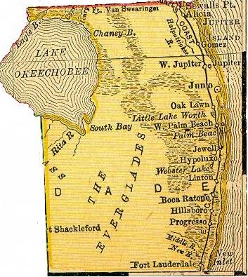
 I find old maps
interesting. For instance, South Florida here used to be one entire
county—Dade with some lovely sounding towns that are for the most part, no
longer around. The upper portion of Dade (from 1895) there to the left
shows such places as Hillsboro (now just a street in Northern Broward),
Hypoluxo (now a street in Palm Beach County), Jewell (which no longer exists
as a town or a street as far as I know) and Progresso (which became Wilton
Manors).
I found these old maps at the Color Landform Atlas of the United
States, which has more modern maps of the United States. I suppose the
webmaster put these scans of an 1985 road atlas on the site, just because.
I probably would have—they're very beautiful.
You have my permission to link freely to any entry here. Go
ahead, I won't bite. I promise.
The dates are the permanent links to that day's entries (or
entry, if there is only one entry). The titles are the permanent
links to that entry only. The format for the links are
simple: Start with the base link for this site: https://boston.conman.org/, then add the date you are
interested in, say 2000/08/01,
so that would make the final URL:
https://boston.conman.org/2000/08/01
You can also specify the entire month by leaving off the day
portion. You can even select an arbitrary portion of time.
You may also note subtle shading of the links and that's
intentional: the “closer” the link is (relative to the
page) the “brighter” it appears. It's an experiment in
using color shading to denote the distance a link is from here. If
you don't notice it, don't worry; it's not all that
important.
It is assumed that every brand name, slogan, corporate name,
symbol, design element, et cetera mentioned in these pages is a
protected and/or trademarked entity, the sole property of its
owner(s), and acknowledgement of this status is implied.
 I find old maps
interesting. For instance, South Florida here used to be one entire
county—Dade with some lovely sounding towns that are for the most part, no
longer around. The upper portion of Dade (from 1895) there to the left
shows such places as Hillsboro (now just a street in Northern Broward),
Hypoluxo (now a street in Palm Beach County), Jewell (which no longer exists
as a town or a street as far as I know) and Progresso (which became Wilton
Manors).

![Glasses. Titanium, not steel. [Self-portrait with my new glasses]](https://www.conman.org/people/spc/about/2025/0925.t.jpg)